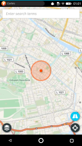
After my first steps with Firefox OS, this time I looked out for a navigation app because proper navigation is to me among the most important services of a mobile phone. I navigated through Mozillas marketplace and so far there are Cartes, Bing Maps, traffc, Maps Online, Find Me Google, Compass +, zMaps and Easy Taxi. Unfortunately, you do not see which one are Free Software and which not. But, after reading the info-pages inside the market place, I found Cartes to be the only navigation app in the market place so far, that is Free Software. So I gave this one a try.
First, I love a lot that it comes with a very easy-to-use interface that is composed of simply one line where you can enter for example an address that you are looking for. Or two lines in case you look for a route. Basically like openstreetmap.org itself. This interface is so much easier to use than the one from my beloved Osmand, which has a much more complex and unintuitive interface. Actually, every time I look for an address in Osmand, I wish there would be something like an easy “one line interface” to find the address I am looking for …
However, I think the difference in search usability derives from one of the most important features that Osmand offers and Cartes not, at least not yet: Offline maps and navigation. Offline maps are much more powerful than online searches, they are faster and work without any dependency on your internet connection. Which is especially important when you are travelling and like to have a full navigation system without roaming charges – anywhere in the world. Also I have to admit that Osmand~ offers multiple times more features and functionality than Cartes, for example OpenStreetMap editing on your device.
But hey, Cartes is a good start and I would love to see further development to give Firefox OS users easy-to-use freedom to OpenStreetMap for their navigation instead of being tied to proprietary services. And, as I can see from updates, there is already a “First attempt at offline use, now viewed tiles are cached an can be reused offline”. Thanks, Maël Lavault, keep the good work going.
BTW: Interesting to see, that Cartes can display satellite images? Where does it take it from? Bing?
